ckf Posted December 16, 2020 Author Posted December 16, 2020 Three below right now in Island Pond. I'll try to get my drone in the air after it warms up to see if IP over. 1 Quote
ckf Posted December 16, 2020 Author Posted December 16, 2020 I said screw it and flew from inside, lol. Both Spectacle (foreground) and Island Pond (background) have frozen over. Quote
ckf Posted December 17, 2020 Author Posted December 17, 2020 Not even a dusting here in Island Pond Quote
ckf Posted December 18, 2020 Author Posted December 18, 2020 It was -4° when I left Island Pond at 6 this morning. At the bottom of Sanderson Hill in West Charleston it was -9°. That created some sea smoke effect on Lake Willoughby's open water this morning. On the downwind side the trees were covered in frost. BTW.. @steve from amherst pretty much zero snow in cow country today. Quote
Platinum Contributing Member steve from amherst Posted December 19, 2020 Platinum Contributing Member Posted December 19, 2020 12 hours ago, ckf said: It was -4° when I left Island Pond at 6 this morning. At the bottom of Sanderson Hill in West Charleston it was -9°. That created some sea smoke effect on Lake Willoughby's open water this morning. On the downwind side the trees were covered in frost. BTW.. @steve from amherst pretty much zero snow in cow country today. Kinda figured that. Lower in VT got some. This yr we are going to try the waterbury area a bit. Lotta cow there too. 1 Quote
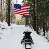
ckf Posted December 24, 2020 Author Posted December 24, 2020 Yesterday afternoon.... before the Xmas meltdown. Quote
ckf Posted December 25, 2020 Author Posted December 25, 2020 Currently 56° and raining here in Island Pond. What little snow we did have evaporated overnight Quote
ckf Posted December 28, 2020 Author Posted December 28, 2020 Currently 34 with light snow falling in Island Pond. Quote
ckf Posted December 31, 2020 Author Posted December 31, 2020 Last night's forecast 1-3 inches for IP amounted to a dusting. Quote
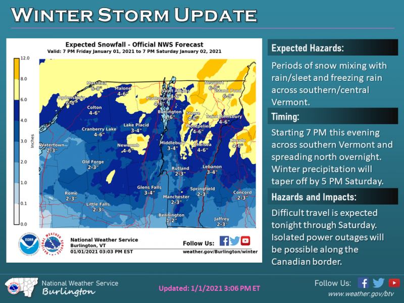
ckf Posted January 2, 2021 Author Posted January 2, 2021 On 1/1/2021 at 3:57 PM, ckf said: About 6" in IP with a little more in upper elevations. Quote
USA Contributing Member $poorsledder$ Posted January 3, 2021 USA Contributing Member Posted January 3, 2021 3 hours ago, ckf said: @$poorsledder$ 8" in Orleans. Awesome! Bringing the sleds up on the 15th. Quote
ckf Posted January 3, 2021 Author Posted January 3, 2021 3 minutes ago, $poorsledder$ said: Awesome! Bringing the sleds up on the 15th. Brighton and Norton are out tonight. Derby's Tucker passed through IP tonight too. Maybe they can get this packed down to form a base for the snow predicted throughout the week. Quote
Gold Donating Member XCR INDY Posted January 3, 2021 Gold Donating Member Posted January 3, 2021 1st post, hope to get approved. Love all the videos in the NEK. My father in law is from the area and still has a camp up off Victory road outside of Burke. Hope to be able to get up there to ride this year. 1 Quote
ckf Posted January 6, 2021 Author Posted January 6, 2021 I just talked to my neighbors this morning. They ice fished Island Pond yesterday. They said that there was only 3" of good ice where they were fishing. Both the father and the son said that they wouldn't ride on it yet. Quote
ckf Posted January 6, 2021 Author Posted January 6, 2021 Unfortunately it doesn't look like any chances of real snow until the around misd January. 1 Quote
Sael Posted January 10, 2021 Posted January 10, 2021 The snow at my stake in Barre Town is down to 4”. The weather forecast for the next week has evening temps just below freezing and daytime temps just above freezing. No snow in the forecast. Absolute bummer. Quote
ckf Posted January 11, 2021 Author Posted January 11, 2021 On 1/10/2021 at 12:46 PM, Sael said: The snow at my stake in Barre Town is down to 4”. The weather forecast for the next week has evening temps just below freezing and daytime temps just above freezing. No snow in the forecast. Absolute bummer. I was just looking at some long range predictions. We may see a little here and there, but not a favorable pattern for the northeast. Hopefully the 1st week of February gets stormy. Here's a summary Quote While there will be some intrusions of cold air into eastern North America over the next week or two, they will be nothing out of the ordinary. Sorry, no polar vortex! There may be a day or two where temperatures end up well below normal, but for the most part, the next three weeks as a whole will likely end up close to normal or even slightly above normal for southeastern Canada and the northeastern United States. Signs continue to point toward western Canada and perhaps the northern U.S. Rockies as the regions that will get into the true Arctic air the last 10 days of this month and into early February. Recently, the true polar vortex has been hanging out over northern Russia and will likely continue to do so this week before it may come more around into far northwestern North America. There will be opportunities for snow with this pattern along the front range of the Canadian Rockies (upslope snow) and in the East as the storm track may be favorable at times with just enough cold air in place. Quote
Recommended Posts
Join the conversation
You can post now and register later. If you have an account, sign in now to post with your account.
Note: Your post will require moderator approval before it will be visible.